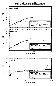
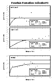
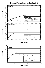
For this case study, the data was divided into eight indicators. For each indicator, experimental and model semivariograms were calculated for the principle and two minor axes. This was done for the full data set and for each formation. The results for indicator #3 are shown here. Of the different indicators, they best show that the spatial statistics indeed are different, though all indicator sets showed this fact to some extent. The top row of semivariograms is for the North-South direction, the middle row is East-West, and the bottom row is vertical.
| Full Data Set | Fountain Formation | Lyons Formation |
|---|---|---|
|
|
|
Visually the semivariograms in the North-South direction are different for the Fountain and Lyons Formations. The ranges are 44m vs. 168m respectively. In the East-West direction they are also different; 111m vs. 64m respectively. Not only are the ranges for the same indicator substantially different, but the principle anisotropy directions are 90 degrees appart
Based on this analysis, it again appears that the zones are distinct.