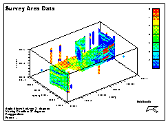
 The field data was derived from several sources: borehole chip samples,
borehole cores, borehole geophysics, seismic tomography between boreholes,
and air permeability measurements on borehole core samples (McKenna, 1994).
The field data was derived from several sources: borehole chip samples,
borehole cores, borehole geophysics, seismic tomography between boreholes,
and air permeability measurements on borehole core samples (McKenna, 1994).
Displayed here are interpreted values of hydraulic conductivity (blue = high, red = low). Although the site crosses two distinct formations, initial work suggestested secondary diagenisis was the stronger controling factor for hydraulic conductivity (McKenna, 1994). For this research, it was felt the formations likely had some control, therefore the data set was divided along the formation contact. The contact was defined based on seismic tomography cross-sections.
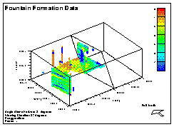
| Fountain Formation Data |
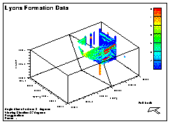
| Lyons Formation Data |